

One thing I find indispensable when it comes to writing historical novels is using maps for my research. I have developed quite an online collection as a result of my past almost ten years of writing. I’ll focus on a few maps I found helpful for my three books which are either published, or will be published, in the first half of 2024.
I write most of my novels—many of them in the mail-order bride category—primarily set in the 1860s through 1900s. The main mode of long-distance transportation at that time was the railroad. One map I use frequently enough that I keep it on my computer wallpaper shows the primary lines built up to the 1870s (just after the Trans-continental Railroad was completed), and the lines built between the 1870s and 1890s. I refer to it as part of my advance planning to make help determine if a connection between two or three points by rail is even feasible.

For two of my books, several scenes in each were set in Columbus, Ohio. Although not the West, I like to use it as one of the places from which my characters originally lived. I found a map with the major cities in Ohio helpful.

For my second book, my heroine was a secondary character in one of my earlier books. In the first book, although she appears in the scenes set in Columbus, I identified her destination as West Virginia. This year, with her as my main character, I needed to develop a backstory and location for the opening scene. I looked for cities that were connected by rail to Columbus during the decade my story was set. I settled on Huntington, West Virginia, which is across the Ohio River from the state of Ohio. This city was developed as a railroad terminal for a Virginia-based road so that freight could be carried across the river and continue on the myriad of rail lines available in Ohio.
As a side note, Huntington, West Virginia, was named after the same Collis Potter Huntington who was one of the "Big Four" who financed the Central Pacific Railroad, the western portion of the Transcontinental Railroad. Once that project ended, he moved on to other railroads in the East.

For my Rejected Mail-Order Bride book, I needed a location farther west than West Virginia, but where the return trip after she is rejected will take her through Columbus. I looked for locations in Wisconsin. The issue I ran into was that, although Wisconsin still had a lot of wilderness areas, many towns were settled by the 1850s or earlier. If a settled area, there might not have been a big need for finding wives through correspondence.
I searched until I found Marshfield, a town not developed until 1872 when the Wisconsin Central Railroad built a line to connect Chicago with Lake Superior. The railroad chose Marshfield to be a rail stop for taking on fuel and water, and the town developed from there. I love finding railroad maps like the one below.


My third book is my covered wagon story, the third I have written for the Prairie Roses Collection. Each of my stories followed the one before. I started by gathering the maps for the major trails, like the one below, that I already had on file for the major trails.

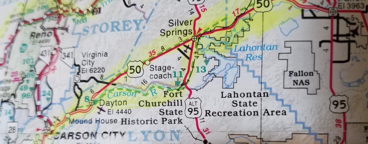
Last year, when I began looking for maps that showed greater detail of the California Trail, one interesting source I stumbled across were the Triple-A maps. Along with current streets and features, several show some of the early trails. I used the one below for the section of the California Trail that took my characters to Carson City. That, combined with research of the physical characteristics of the landscape, helped me better describe the setting as the small train crossed the Forty Mile Desert and where exactly they finally reached the Carson River.
These are just a small sample of the maps I have searched for and keep on file to help flesh out the details of my books.

Jocelyn’s Wedding Dilemma is now available for sale as an ebook and at no additional cost with a Kindle Unlimited subscription. To find the book description and purchase options, please CLICK HERE

My next publication will be Florence’s Good Deed, Book 6 in the Rejected Mail-Order Brides series. Again, I placed part of this story in Columbus, Ohio. Florence and Asher were introduced as secondary characters in my last year’s book, Elise. That was when I first became familiar with Columbus. Parts of this book took me to Huntington, West Virginia; Marshfield, Wisconsin; Cheyenne, Wyoming Territory; and Helena, Montana. I sought out maps for all locations, particularly the railroad maps I needed.
Florence’s Good Deed is now on pre-order with a release date of April 15, 2024 (tax day). To find the book description and link, please CLICK HERE

My third book for which I have already started gathering maps is Lucy, Book 46 in the Prairie Roses Collection. This book takes me from Lawrence, Kansas, during the Civil War to California.
Lucy is now on pre-order with a release date of May 2, 2024 (yes, my writing schedule will be tight). To find the book description and link,
please CLICK HERE
3 comments:
HI Zina: Kudos to you for all the logistical research you do for your books. Love maps too. Interesting post, thanks for sharing.
Thand you, Gini. I'm glad to hear you enjoyed the post. By reviewing some of your posts, it appears we have common interests in book settings. Best wishes. Robyn Echols writing as Zina Abbott
Fascinating. I love maps, too, and use them every time I write a book. Sometimes it's hard to find just the one you want! What did we do without Google? I know I had zillions of book I looked through to find stuff -- or not find stuff. Thanks for including this wonderful information!
Post a Comment